
RadarUSA (Version 1.2) - buy on android market ($1.00)
Android Mobile Phone App for Android 2.1 and later
USA National Weather Service rain radar viewer.
Simple and easy to use.
Works best with a touch screen (to zoom and drag it) and a wifi connection.
It does not work on android 3.x tablets at the moment
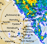
RadarUSA displays the most recent doppler weather radar (rain) image
for a selected location.
It shows a map of your area with an overlay of
the rain radar image.(see radar explained)
The app opens straight up into the most recent map for the selected area.
(The images are usually updated every 6 to 10 minutes).
The map can be zoomed in and out and can be dragged around the screen.


Rainfall colors are green (lightest), yellow, orange (heavy), red, purple (downpour).
Blues are NOT rain.
The menu options:-
north, south, east, west - move to the next radar location in that direction.
States - open up a list of states for selection of location.
284mi radius - increases the coverage of the image from 124 to 284 mile radius.
.


Two image sizes are available - 124mile radius (default) and 284mile radius.
The UT and local time is shown at the top of the image.
The 284mile option is about half an hour behind the current time owing to android not fully supporting animated gifs.
.
For quickest display, it is preferable to be on a wifi connection.
Add it to your home page and it is there at your fingertips to view at a moments notice.
.
INSTRUCTIONS for USE:-
The very first time the app is run, it fires up in the 'States' 'menu'.